Domains and Datasets
What is a Domain?
A Domain is a category that contains entities that are closely related. In the Open Data Hub, each domain roughly identifies one social or economical category; the domains intended as sources for data served by the Open Data Hub are depicted at the bottom of Figure 1.
Currently, the domains that can be accessed through the Open Data Hub are:
- Mobility, this domain contains data about public transportation, parkings, charging station, and so on.
- Tourism: data about events, accomodations, points of interest, and so on.
- Other domain: a special category that encompasses domains that do not fall in any of the above category.
Each domain is composed by datasets, each of which contains data that provide useful information for the domain.
It is important to note that there is no clear separation between two domains. For example, data about public transportation belong to the Mobility domain, but are also useful for the Tourism domain.
The goal of the Open Data Hub project is to make available datasets containing data about the South Tyrolean ecosystem, to allow third parties to develop novel applications on top of them, consuming the exposed data. These applications may range from a simple processing of datasets to extract statistical data and to display the result in different graphic formats like pie-charts, to far more complex applications that combine data from different datasets and correlate them in some useful way.
As seen in Figure 1, data originate from different domains (Mobility, Tourism, and so on); they are gathered from sensors and packed together by Data Providers. Sensors can be for example GPS devices installed on buses that send their real-time geographic position or a small electronic device on a plug of an e-charging station that checks the if the plug is being used or not, to let people know that the charging outlet is available.
Datasets are accessible through a REST API, the URL of each endpoint is given along with other information in the description of each dataset, see the lists of datasets in the remainder of this section.
Data Providers
A Data Provider is any entity that shares their Open Data
with the Open Data Hub project, allowing their free reuse (ideally
under a free licence like  or
or  ). Data can be picked up by
any third-party to build their application. These entities can be
private companies or enterprises, public bodies, and even private
citizen.
). Data can be picked up by
any third-party to build their application. These entities can be
private companies or enterprises, public bodies, and even private
citizen.
The updated list of Data Providers that contribute to the Open Data Hub is available on the Open Data Hub’s home page: https://opendatahub.com/community/
Datasets, Open Data, and Licenses
The resources that are part of the Open Data Hub Project are subject to different licenses, which are described in section Licenses for Open Data Hub resources. Derivative material built using Open Data Hub material is also subjected to different licenses, depending on its purpose, as shown in Figure 7.
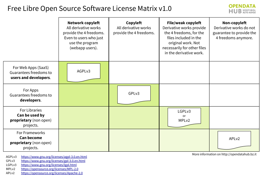
Figure 7 Licenses for the Open Data Hub and derivative material.
A large part of the Open Data Hub resources is represented by the datasets. While some of datasets have been provided for testing purposes or for internal use only, most of them are made of open Data only.
The goal of the Open Data Hub project is to expose only Open
Data and the Open Data Hub team members always suggest to use a
license to Data Providers releasing datasets, it is not yet possible
for the Open Data Hub team to guarantee the availability as Open Data
of all the data in the datasets, because the data licensing and its
distribution rights are decided by the copyright holder of each
dataset.
Since some of the datasets may contain data that can not be
distributed by the Open Data Hub team under an open licence like,
e.g., or , a user will be able to retrieve from each
dataset only those data that are distributed as Open
Data. The response to a query is in JSON format (although CSV
output can be forced) and is always licensed as Open
Data. However, the response may include resources like links to web
pages, streams, or images that are subject to a different, even
proprietary, licence. For more information about this topic, there is
a dedicated section.
The FLOSS four freedoms
The four essential freedoms are the four basic principle to which a software program must comply to be defined free software. As stated on the What is free software? web page (on which you can find a lot more information and details), they are:
The freedom to run the program as you wish, for any purpose
The freedom to study how the program works, and change it so it does your computing as you wish. Access to the source code is a precondition for this.
The freedom to redistribute copies of the program so you can help others.
The freedom to distribute copies of your modified versions to others. By doing this you can give the whole community a chance to benefit from your changes. Access to the source code is a precondition for this.
Licenses for Open Data Hub resources
The Open Data Hub Project processes dataset, possibly supplied by third-party sources (i.e., Data Providers), which may contain closed data; however, only Open Data are returned to the users’ queries.
According to the main goal of the Open Data Hub Project, we have defined licenses for its different components and we use badges across the documentation for a better visibility. As a rule of thumb, we try to do our best to deliver Open Data, by developing Free/Open Source software that is publicly available on github, and by using an Open Standard for the API used to access data.
These licenses are applied to the Open Data Hub components:
- All the software released within the Open Data Hub is Free software and
complies with the GPLv3 license.
 Code repositories can be
found at https://github.com/noi-techpark.
Code repositories can be
found at https://github.com/noi-techpark. - The Datasets currently expose only Open Data that are in
the public domain, so they are released as CC0.
- The APIs have no license yet, since we are in the process to define which among the CC licenses could fit best. See Figure 8 for an overview and quick description of CC licenses and derivative material.
CC0 Licensed Data
Open Data Hub provides a live updated table about the number of CC0 licensed data it contains. Please note, this data is calculated on some datasets and does not consider all datasets of the whole Open Data Hub yet.
https://databrowser.opendatahub.com/Home/LicenseStatus
Note
There is an additional clarification about the licence for any content that is retrieved from the datasets in JSON format, which is detailed in Section License of the JSON Responses.
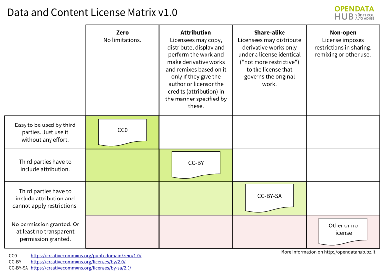
Figure 8 Creative Common Licenses and derivative material.
License of the JSON Responses
Whenever you query the data in the Open Data Hub, the snippet that you
retrieve always includes a block of information called
LicenseInfo, similar to the following one:
1{
2   "LicenseInfo": {
3     "Author": "",
4       "License": "CC0",
5       "ClosedData": false,
6       "LicenseHolder": "https://www.lts.it"
7   }
8}
The highlighted line shows a licence, which in this case is CC0, i.e., public domain and therefore freely reusable.
This block is always included as a child node within a JSON record that starts with an ID and a number of additional information, which may include also hyperlinks to resources that are external to the Open Data Hub, like in the following snippet–shortened for the sake of simplicity, which refers to a webcam and contains a link to an external provider where to find actual resources (e.g., streams and images) from that webcam.
 1{
 2  "Id": "D3659E1F111C4CDB2EC19F8FC95118B7",
 3  "Active": true,
 4  "Streamurl": null,
 5  "Webcamurl": "https://webtv.feratel.com/webtv/?&pg=5EB12424-7C2D-428A-BEFF-0C9140CD772F&design=v3&cam=6323&c1=0",
 6  "LicenseInfo": {
 7    "Author": "",
 8    "License": "CC0",
 9    "ClosedData": false,
10    "LicenseHolder": "https://www.lts.it"
11  }
12}
Whenever hyperlinks like the one shown in line 5 above
appear, it must not be implied that the license mentioned in the
LicenseInfo block (again, CC0) is applied to them:
everything contained in that link may be covered by a different
licence.
Indeed, the Licence mentioned in LicenseInfo
nodes refer only to content of the parent node–i.e., the one that
starts with “Id”, not to the content of any of the other
children nodes, including Streamurl and
Webcamurl.
APIs Terms of Service
The Open Data Hub project is already used in production for NOI internal projects, and in particular it is the data hub used by the South Tyrolean tourism portal, https://www.suedtirol.info/en/.
The public API are in early development and therefore should be still considered as a beta version. If any third party would like to use a stable version of the APIs in its production environment, a special agreement must be signed with NOI techpark. You can contact for any information.
Authentication
The authentication layer is currently intended for internal use only. All data in the dataset that you can receive from the Open Data Hub are free to use and do not require any type of authentication.
Datasets
Changed in version 2022.06: API v1 for Mobility domain are no longer available.
Changed in version 2022.10: Removed information about datasets
The list of datasets and all the information associated with them have been moved to the Open Data Hub main web site with the same categorisation, hence you can find them in the following pages:
- Mobility / Mobility datasets
- Mobility / Traffic datasets
- Tourism datasets
- Other datasets.
To access the dataset, please refer to the How to Access Mobility Data With API v2 and How to access Tourism Data? howtos, which helps you getting started in retrieving data from the Mobility and Tourism datasets, and to the other howtos are available in the dedicated section.
Technical Information for Mobility Dataset and Technical Information for Tourism Dataset are still available in this documentation portal.